San Salvatore

World's first Freezy Frame
Table of contents

Italiano

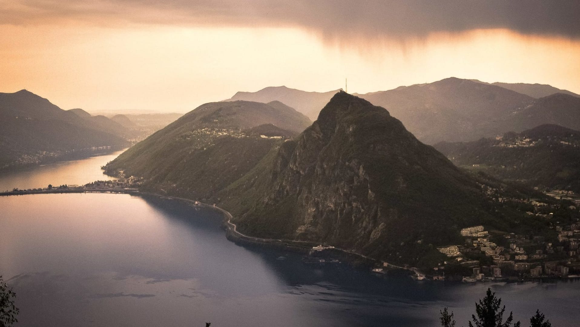
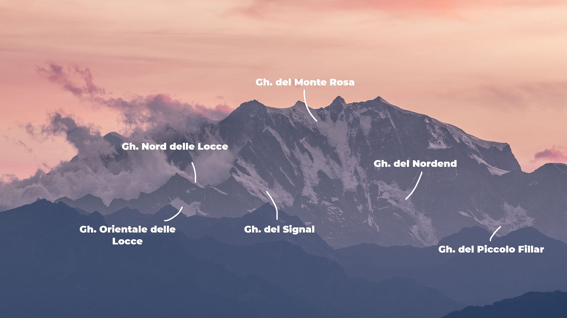
Siamo orgogliosi di installare il primo Freezy Frame al mondo sulla cima del Monte San Salvatore a Lugano. Il panorama spettacolare si estende dalle Alpi italiane del Piemonte alle Alpi Pennine della Svizzera. Si possono osservare un totale di 16 ghiacciai! La cornice gialla dà quella piccola spinta necessaria non solo per guardare un panorama alpino, ma per vedere effettivamente i ghiacciai. Quindi andate avanti: guardate, vedete e posate con loro attraverso la nostra cornice e condividete le vostre foto sui social network con l’hashtag #recognice!

English

We are proud to install world’s first Freezy Frame on top of Monte San Salvatore in Lugano. The spectacular vista stretches from the Italian Alps of Piedmont to the Pennine Alps of Switzerland. Clear skies allow you to observe and be mesmer.ice.d by a grand total of 16 glaciers! The frame gives you that little push needed to not just look at an Alpine panorama, but to actually see the glaciers. So go ahead: look, see and pose with those icy giants and share your best pictures with #recognice!

San Salvatore's 16

The 16 glaciers visible from Monte San Salvatore in Lugano, from southwest to northeast. Pictures kindly provided by U. Raz.

Previous
Next

Etymology

Enjoy the surprising and often amusing origin of the glacier names! We want to warmly thank Prof. em. Dr. Iwar Werlen (University of Bern) and the Region Piedmonte for their outstanding and personal.iced support.

The term “pioda” or “piode” is used in Valsesi to indicate “slabs of rocks” (in Piedmontese also “losa”). In fact, in the Monte Rosa area, the gneissic rocks are often massive, sometimes fractured into regular slabs, used since ancient times as an architectural element (especially as roofing).

Derives from sèṡia s. f. [lat. scient. Sesia, nome di genere, der. del gr. σής “tignola”]. – Common name of lepidoptera (also known as butterflies) of the sesidi family, parasites of fruit plants, pear trees and apple trees (in Italian, “sesidi del pero”, “sesidi del melo” etc.). A popular saying about Monte Sesia goes back to the “mountain of fairies and witches”: in fact, the pinnacles, caves and woods give an enchanted atmosphere, and those who know how to capture the magic of nature believe that this pictorial etymology is not entirely false.

Coming soon

Though the Italian Rosa as well as the French Rose both mean “pink”, the name is a false cognate derived from the Franco-Provençal Valdôtain patois word rouése, meaning “glacier”. On old maps as late as 1740, the mountain was named Monte Bosa and even Monte Biosa by the inhabitants of Val Sesia.

Ghiaccaio del Nordend is named after the Nordend peak in the Monte Rosa Massif by Ludwig von der Welden (The Monte Rosa. Vienna 1824, 37f.). This peak is literally situated on the north of the Dufour peak, the highest point of Switzerland (4’634m).

Located in the Italian region of Piedmont, this glacier has its name primarily from the Kleiner Fillarhorn peak; beside it, there is the Grosse Fillarhorn peak. Both peaks are however in the Swiss municipality of Zermatt. Fillar is furthermore the name of an Alp Fillar on Italian territory. Paul Zinsli (in “Südwalser Namengut”, Berne, 1984, p. 301) knows the word but does not give any interpretation. It can be assumed that the Latin adjective “villāris” means “belonging to the estate” (here probably: belonging to the Italian village Macugnaga) (cf. French Etymological Dictionary Vol. 14, p. 456). This interpretation is uncertain.

Located in the Italian region of Piedmont, it probably got its name from the Roffel Horns and the Roffel Pass, which in turn go back to the Roffel Alp in Italian territory. Paul Zinsli (in “Südwalser Namengut”, Berne, 1984, 578f.) attributes “Roffel” (and “Rofal” in his case) to the main “Rufine” lemma which means “earth slippage, mud flow, scree slope”, which then again probably goes back to “rovina” and “ruina”.

The glacier is called Seewjinen Glacier, however in the VSNB database it is referred as the “Seewjinugletscher”. Its name derives from “Ze Seewjinu” (VSNB), Zen Seewjinen (“near the small lakes”), which probably gave the name to the Seewjinenhorn. From the glacier, the Seebach flows into the Saaser Vispa.

The glacier is called Schwarzberggletscher, however in the VSNB database it is referred as the “Schwarzbärggletscher”, in the area of the Swiss municipality of Saas Almagell. The glacier probably got its name from the Schwarzbärgalpe (above the Mattmark reservoir), which probably also gave the Schwarzberghorn its name.

The Strahlhorn peak (in the Swiss municipality of Zermatt) is listed in the database of the VSNB as “ts Straalhore”. At its bottom lies an ice field, which is probably named after the glacier. “Strahl” is usually the dialectal name for a rock crystal or other rare minerals that it has there according to the description. Besides this Strahlhorn, there are several other places named like this in the Upper Wallis region.

Only the Fluchthorn peak (on the Swiss municipality of Saas Almagell) is listed, at the foot of which there is an ice field. In the VSNB file, it appears as “ts Fluchthoru”. On its side is the so-called Fluchtpass. The main lemma “Fluchthoru” only occurs here and is otherwise missing in the Upper Wallis village and field names. An interpretation is therefore not possible for linguists.

The glacier is called Allalingletscher below the peak of Allalinhorn. In the VSNB database, it appears as the “Aleliingletscher” and it belongs to the municipality of Saas Almagell. It is named after the massif Allalin (dial. Alelii with final emphasis, which suggests a pre-German origin), which probably does not originate from the massif but from an alpine pasture. The name gave rise to the so-called Saracen hypothesis, which in the linguists’ opinion is not correct.

The glacier is located near the Allalinhorn peak and belongs to the Swiss municipalities of Saas Almagell and Saas Grund. In linguistic files, it appears as the “Holöübgletscher”. The Holöübbach flows from the glacier into the Saas Vispa. The field name “Holöüb” is otherwise not documented. It probably means ‘the high foliage’, whereby ‘foliage’ is unclear, but probably simply means the foliage (green alder) above the tree line.

The glacier is probably named after Fee, the original name of the Swiss village of Saas Fee. “Fee” is not the German “Fee” (“fairy” in English), but goes back to a Latin word “feta” ‘(female) sheep’. The intervocalic /t/ disappeared early.

This glacier is located between the peaks of Lagginhorn and Fletschhorn in the Swiss municipality of Simplon. Jordan (2006, p. 266 knows it as a holuntrift glacier and makes it a holuntrift.) Our linguist sources know the area “Holutrifft” as the “Holutrift”, a sheep pasture with hollow (Simplon), which is located below the glacier.

It is located between Monte Leone and the Breithorn. For Erich Jordan (in “Orts- und Flurnamen Simplon Süd”, 2006, 294 as Alpjärgletschär), it is located in the Swiss municipality of Zwischbergen above the area “t Alpje, die Alpjen” (name of a larger alpine area)’ (cf Jordan, 2006, p. 265 as Alpjä).

Glacier evolution

Below you’ll find the evolution of glaciers with the longest measurement records. Zoom or select individual glaciers and hover over the figures to see the numbers. Double clicking resets the whole plot. 

Evolution of the surface area of four glaciers in the panorama since the beginning of measurements (Allalin:  1946, Schwarzberg:  1932, Hohlaub:  1932, Seewjinen:  1946). For a more intuitive visualisation, the surface area is calculated in the number of soccer fields which would be necessary to cover each glacier. A soccer field has an area of 7’140 m2. The red line corresponds to the total sum of soccer fields lost by all four glaciers combined.

Annual length change of five glaciers since the beginning of measurements (Piode:  1915, Fee north:  1884, Seewjinen:  2006, Schwarzberg:  1909, Allalin:  1884). Length change is measured each year as the change in location of the glacier tongue with respect to the last measurement of the glacier tongue. A positive change indicates an increase in glacier length, a negative change a decrease in length. For a more intuitive visualisation, the length is calculated in number of blue whales, which would be necessary to lay between the two points of measurement. The longest known blue whale measured 29.9 m. Taking the cumulative sum over all of these blue whales (i.e., stepwise changes in length) shows the overall evolution of the location of the glacier tongue since the beginning of measurements. The red line corresponds to the cumulative sum for all five glaciers combined.

The surface area of a glacier can be subdivided into two zones: the accumulation and the ablation area. Simply put, the accumulation area roughly covers the top third of the glacier and corresponds to the part of the glacier, where snow survives the summer and is gradually compacted by the weight of subsequent new snow. This is how it slowly turns into glacier ice. The ablation area corresponds roughly to the lower two thirds of the glacier, where winter’s snow doesn’t survive the following summer and therefor the glacier ice melts during summer. The line that separates these two zones is called the ‘equilibrium line altitude’ (ELA). When the ELA rises, a larger part of the glacier is exposed to melting and new ice is formed only in a smaller part. Overall the glacier looses ice mass when the ELA rises. The evolution of the ELA over time therefore contains useful information regarding the overall glacier ‘health’.

Glacier evolution

On the desktop version of this webpage, you will find interactive plots. Because of the size of your phone, the plots projected here are only presented in an image format. 

Below you’ll find the evolution of glaciers with the longest measurement records. Click on the figure to see it in full size and resolution.

AREA_soccer_SS

FRONT_VARIATION_tt_SS

ACC_AREA_SS

Glaciers in numbers

For this table we only included the seven glaciers of which we have data for each parameter. By clicking the boxes, you can sort the data. The WGMS ID refers to the number under which the glacier is listed in the database of the World Glacier Monitoring Service. A “0” means we don’t have accurate data for this parameter.

Glacier nameCountryMeasurement yearLength (km)Area (km²)Max. elevation (m)Min. elevation (m)WGMS ID
HolutriftSwitzerland20111.640.5369725705731
Strahlhorn-EastSwitzerland20091.030.55351230775448
NordendItaly19751.80.63350021001211
SesiaItaly19752.81.07400027001210
SeewjinenSwitzerland20091.841.42322827193333
AlpjerSwitzerland20111.872.17341828175736
Fee-S-IISwitzerland20094.597.33401925764589
PiodeItaly20092.2044363470619
SchwarzbergSwitzerland201705.135662680395
AllalinSwitzerland201809.6541802693394
HohlaubSwitzerland201702.13402228503332

Find and share!

You get here by taking the fantastic funicular from railway station Paradiso or you can hike up. Pose as much as you like and share your pictures on your social channel using #recognice and #montesansalvatore!

Sign up for the newsletter to be the first to hear about new frame locations!

Questions we can readily answer

Sebastian Marbacher designed the frame. He studied industrial design at Zurich University of the Arts and founded his own office in 2013 in Zurich, Studio Sebastian Marbacher. In 2017, he was awarded the prestigious Swiss Design Award by the Swiss Federal Office of Culture.

For Sebastian, the size of the Freezy Frame “is motivated by two aspects. First, it should mark a presence in a natural as well as in an urban environment. And second, it should be a suitable frame for a photo of a single person as well as provide enough space for a small group – from selfie to groufie. Color wise, we have chosen a luminous tone that fits well into the varied color palette of nature”. Note that the frame material is 100% recyclable.

On the front side, one reads the name of the corresponding panorama as well as #recognice, so you can share your images on social medias.

On the back side, one reads a brief description of Recogn.ice in four languages (EN, IT, FR, DE) and a QR-code. By scanning it, you will land directly on our dedicated webpage and learn more about the corresponding panorama, for instance the dynamics, the altitude and etymology of the glaciers visible.

First of all, our installations are made with 100% recyclable materials. We also offset the CO2 emissions that have occurred during production and transport.

In the case of Lugano, we are fixing our frame to an existing terrace. However, we also possess a mobile frame, which can be installed temporarily in key locations.

By future installation of frames in city centres, we want to show you that you can observe and enjoy this beautiful panorama even from urban regions. One does not have to travel far away to spot and recogn.ice glaciers!

Our agreement is set for at least 3 years, so that people can over time recogn.ice themselves the evolution of the surrounding glaciers. Lugano can prolong this period, since it is the owner of the frame.

This installation is a world premiere. In the course of summer 2019, we first contacted Michela Sormani. She’s helping the Ticino cities to obtain and/or renew their label “Citta dell’Energia”. She sounded enthusiastic and introduced us to Ugo Bernasconi who has been in charge of this program for the City of Lugano. He immediately saw the potential of a frame for his city and we starting discussing the very location and the feasibility. We concluded that the top of Monte San Salvatore would offer a splendid panorama, so Ugo convinced all the relevant stakeholders to obtain their support: City, Funicolare San Salvatore and Confraternita di Santa Marta e della Buona Morte. We want to once again express our huge thankfulness to all partners, and in particular to Ugo Bernasconi for believing in us and making things very easy.

This Freezy Frame is supported by the

Città di Lugano & Monte San Salvatore

To improve our website, we too, use cookies. By browsing this website you agree to the use of cookies.